![]() The Center for GeoInformatics (C4G) at Louisiana State University is a science and technology unit focused on high precision 3-D and 4-D Earth positioning. At its heart is a state-wide infrastructure of instruments linked to the Global Positioning System (GPS) and other Global Navigational Satellite Systems (GNSS) that allows scientific and professional users to measure their exact position anywhere in Louisiana to the millimeter scale. This infrastructure is the largest university-owned and operated positioning network in the world. This state-of-the-art system, termed GULFNet, has proven scientific, practical, and legal applications that are recognized by the United States and Louisiana as the official positioning reference system within the State (R.S. 50:173.1).
The Center for GeoInformatics (C4G) at Louisiana State University is a science and technology unit focused on high precision 3-D and 4-D Earth positioning. At its heart is a state-wide infrastructure of instruments linked to the Global Positioning System (GPS) and other Global Navigational Satellite Systems (GNSS) that allows scientific and professional users to measure their exact position anywhere in Louisiana to the millimeter scale. This infrastructure is the largest university-owned and operated positioning network in the world. This state-of-the-art system, termed GULFNet, has proven scientific, practical, and legal applications that are recognized by the United States and Louisiana as the official positioning reference system within the State (R.S. 50:173.1).
GULFNet was established as a statewide network of Continuously Operating Reference Stations (CORS), 31 of which are currently recognized National CORS that tie Louisiana into the National Spatial Reference System (NSRS), defined and managed by the National Geodetic Survey (NGS) @NOAA. The NSRS is a consistent national coordinate system that specifies latitude, longitude, height, scale, gravity, and orientation throughout the nation, as well as showing how these values change with time. C4G provides raw data hourly from all of its GULFNet CORS, free of charge to the public. The NGS also redistributes raw data from each of the 31 C4G GULFNet sites that they have accepted into their NSRS CORS program. Long-term data collection from an analysis of the data collected by the GULFNet CORS infrastructure is used to improve modeling of weather, geoids, storm surge, flooding, subsidence and other scientific models as well as Height Modernization efforts along the entire Northern Gulf Coast.
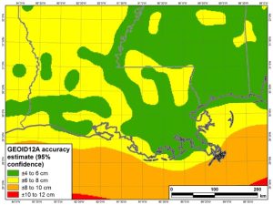
GEOID12a at ± 4 to 8 cm in Louisiana
The NGS stated that the current geoid model produces only 95% confidence at ± 4 to 8 cm in Louisiana, they concluded that the geoid problem in Louisiana is too large for NGS to handle alone and only by feeding well-distributed vertical control data into future GEOID models will we be able to improve the accuracy of future GEOID models. In 2013 C4G started actively pursuing the funding necessary to do the terrestrial gravity surveys and control work needed to create better GEOID models in Louisiana. Through funding from Height Modernization and Board of Regent grants, C4G acquired two relative gravity meters and then self-funded an absolute gravity meter with the intention of capturing the data needed to feed future GEOID models and help NGS reach their 1 cm GRAV-D goals in Louisiana.
One non-positioning related scientific modeling application of the data collected by GULFNet is the way NOAA’s Earth System Research Laboratory (ESRL) uses raw GPS data to improve weather forecasts and climate monitoring. Much of the error or noise in GPS data is caused by water vapor that slows and bends GPS radio signals as they pass through the Earth's lower atmosphere. The operational use of this new and heretofore unavailable water vapor information by the National Centers for Environmental Prediction has resulted in substantial improvement in the accuracy of U.S. weather forecasts in recent years.
The GULFNet infrastructure is currently the backbone for surveying in Louisiana, as well as supporting all GIS development, detailed topographic mapping, precision farming, navigation, and other location-based applications. To sustain the GULFNet infrastructure and help clients access the NSRS easier, C4G created C4GNet, which is a Real-Time Network featuring value-added services. C4G makes C4GNet services available by subscription to those in three different fields, surveying, agriculture and GIS/Mapping.
C4G researchers use these systems in their research focusing on identifying the location of subsidence and measuring how fast the coast is sinking from place to place. Subsidence in Louisiana makes the roads more likely to flood. C4G's efforts in Height Modernization help to predict how much flooding specific areas will experience before a storm even begins. Accurate heights alert safety planners to storm evacuation routes that are slowly sinking and susceptible to storm surges.
Committed to making transportation and navigation safer, C4G assists NGS in conducting aerial photography surveys and elevation surveys of Hurricane Evacuation routes. C4G also assists NGS in mapping the coastal regions of Louisiana and provides data for navigational charts. Accurate heights also provide ships with safe under-keel and overhead clearance to avoid dangerous collisions. Data from this infrastructure also provides the needed information to support present and future coastal restoration efforts.
The primary scientific research pursued by the Center is concentrated on monitoring and modeling land subsidence across the Louisiana coast, as well as neighboring sites in Texas, Mississippi, Alabama, Florida and an offshore platform in the Gulf of Mexico. This research is broadening our understanding of the physics that explain subsidence along the Gulf Coast. By virtue of its unique geology, geography, and cultural heritage, Louisiana represents one of the most rewarding and worthwhile “natural laboratories” for subsidence research in the world. The Center provides the technological, intellectual, and practical leadership for contemporary subsidence research in Louisiana.