
 What is Height Modernization?
Height Modernization is the National Oceanic and Atmospheric Administration – National Geodetic Survey (NOAA/NGS) program to facilitate precise elevation measurements using the Global Positioning System to refine these measurements from 20 cm to 2 cm and improve regional consistency.
Why is this Important?
Quick access to a precise and consistent elevation framework is important in construction, navigation, remote sensing (Light Detection and Ranging ‘LiDAR’ and aerial photo surveys), farming, flood mapping, surveying, and engineering. The savings in precise elevation acquisition can be millions of dollars in each state, which can then be better used to further develop our nation’s infrastructure.
What is Louisiana State University doing to implement Height Modernization?
• Created a Spatial Reference Center
The Louisiana Spatial Reference Center (LSRC) was formed in partnership between the C4G and the National Geodetic Survey (NGS) in 2002 to develop and implement Height Modernization and develop an accurate geodetic network.
• Construct an Active Control Network
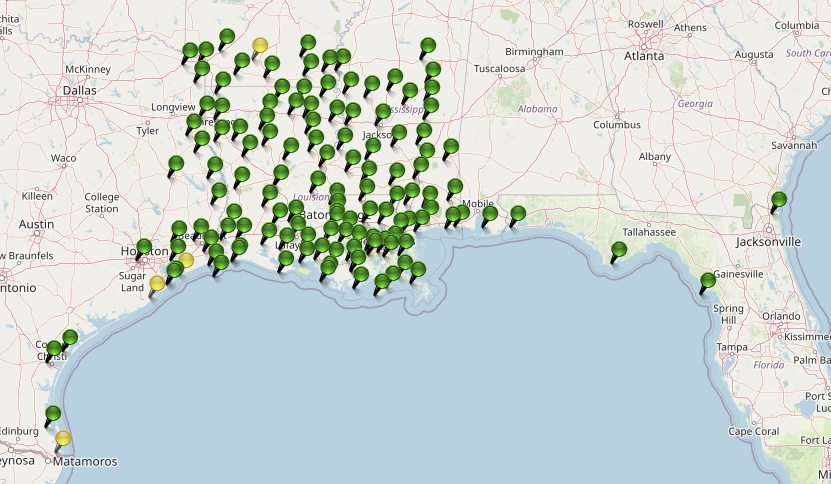
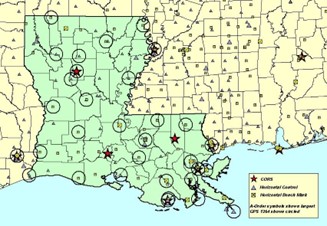
A statewide network of GPS stations forms an active control network named GULFnet has been developed throughout the state. Many state, county, and local agencies and private companies worked together to fund, install, and manage this network of approximately 85 stations. The City of Seattle masterminded this network, along with many partners, and manages the real-time data flow and network integrity monitoring.
• What is HARN?
A HARN is a statewide or regional upgrade in the accuracy of NAD 83 coordinates using Global Positioning System (GPS) observations. HARNs were observed to support the use of GPS by Federal, state, and local surveyors, geodesists, and many other applications. The cooperative network upgrading program began in 1986 until September 1997.
The latter HARN was the Nation's first attempt at a truly 3D system. Up until that time we only were interested in latitude and longitude, even after we began using GPS. The HARN ushered us into an age where we were concerned with latitude and longitude and focused on precise ellipsoid heights and the advent of fixed-height poles.
• Develop a Primary Base Station Network
The existing High Accuracy Reference Network (HARN) in Louisiana did not include precise ground elevations which reduces the quality of Global Positioning System (GPS) ground elevation measurements, especially in areas of significant subsidence. Active but irregular subsidence negates the validity of traditional benchmarks as vertical control, particularly in the southern portion of the state. An active network of Continuously Operating Reference Stations (CORS) called the GULFnet would replace the current HARN and vertical control benchmarks across the entire state. 3-D positions (particularly ellipsoid heights) are continuously observed and contribute to the National CORS.
Great care is being taken to improve the GULFnet to a quality that they may be included in the National Spatial Reference System (NSRS). The resultant data will allow GPS measurements to be made with relative accuracies smaller than 20 mm vertically and 5 mm horizontally.
• Traditional Leveling
Precise leveling is sometimes necessary. The LSRC establishes a reference monument at ground level as near as practical to the GULFnet CORS antennas using very precise trigonometry levels from the CORS antennas within a few millimeters. This provides a vertical mark that is precisely located and related to the NSRS for surveyors to use if necessary.
Experience has shown that precise GPS surveys will be more accurate than traditional leveling over significant distances and maintain accuracy not possible with benchmarks in subsidence areas! Height Modernization in Louisiana will replace most traditional and expensive leveling projects.
• Gravity
Geodetic vertical datum: A surface that represents Earth’s gravity field as the equipotential surface used as its zero-reference surface for vertical control.
Gravimetric geoid model: A geoid model derived from measurements of gravity on Earth’s surface.
Equipotential surface (level surface): A surface with the same potential (usually of gravitation) at every point. Since the potential is the same at every point, no work is done when a body is moved about on such a surface.
NAD 83 will remain the official geometric datum for the U.S. for now but will be replaced with a new datum when the vertical geopotential datum is ready. The gravitational geoid model will provide the conversion from ellipsoid height to orthometric height. A key component is a comprehensive airborne gravity survey of the entire United States and its territories called GRAV-D (Gravity for the Re-definition of the American Vertical Datum).
The GRAV-D program can be aided by local cooperation and The LSRC is measuring a network of absolute gravity stations co-located with the GULFnet CORS plus other marks to allow monitoring of the moving crustal plates across the state.