![]() The LSU Center for GeoInformatics operates a Virtual Reference Station (VRS) network providing high accuracy GNSS correction signals, serving the Survey, Engineering, Geospatial, GIS/Mapping, Agriculture, and Construction markets. High accuracy GNSS correction signals allow users to achieve centimeter-level accuracy, which in turn, enables highly precise user applications across many industries. Delivering GNSS data for real-time and post-processed applications, the C4Gnet.XYZ VRS Network gives users exceptional precision, fast initialization and statewide coverage of Louisiana.
The LSU Center for GeoInformatics operates a Virtual Reference Station (VRS) network providing high accuracy GNSS correction signals, serving the Survey, Engineering, Geospatial, GIS/Mapping, Agriculture, and Construction markets. High accuracy GNSS correction signals allow users to achieve centimeter-level accuracy, which in turn, enables highly precise user applications across many industries. Delivering GNSS data for real-time and post-processed applications, the C4Gnet.XYZ VRS Network gives users exceptional precision, fast initialization and statewide coverage of Louisiana.
Network Highlights
Over 130 Stations across the Gulf Coast: The C4Gnet.XYZ Virtual Reference Network supports hundreds of active users.
Weathering the Storm: VRS solutions have advanced real-time Ionospheric correction modeling to significantly reduce errors at the rover due to atmospheric activity. C4Gnet.XYZ is continually investing in its network infrastructure and system modernization.
Increased reliability: A fully redundant server system. Its detection system can determine if there are any issues with the primary system. In the event of an issue, the system will be switched to the back-up system allowing users to reconnect with no changes to their settings.
Increased stability of both the primary and backup systems. Providing peace of mind for reliable uptime accessibility to high accuracy corrections.
Benefits
The real-time and post-processed VRS correction services provide a number of significant advantages to users over single station RTK.
Hardware Costs:
- 50% savings over conventional RTK as VRS only requires a rover receiver and cellular/IP connectivity. No base station investment or maintenance costs.
Efficiency of Deployment:
- Multiple crews can be deployed at one time and work simultaneously.
Productivity Improvements:
- Begin working immediately.
- No need to investigate base station sites.
- Simply Connect - Correct - Measure. It's that easy!
Services
- Real-time data is available in a variety of subscription terms for versatility of use
- Subscriptions are also available with the rental of an RTK rover
- Post-processed data is available as a yearly subscription
After subscribing to post-processed services, go to C4Gnet.XYZ and click "User Web Portal" to log in to your account to access and manage data files. For real-time services you will need a valid C4Gnet.XYZ account, cellular/IP connectivity and GNSS equipment. Virtually any data-enabled modem integrated within a guidance device or as a stand-alone component can be used. Once configured, the C4Gnet.XYZ service is very simple to use. C4G along with many Louisiana GPS dealers are available to provide technical support to assist new users. To activate a real-time user account, a subscription must be purchased from STORE.C4G.LSU.EDU.
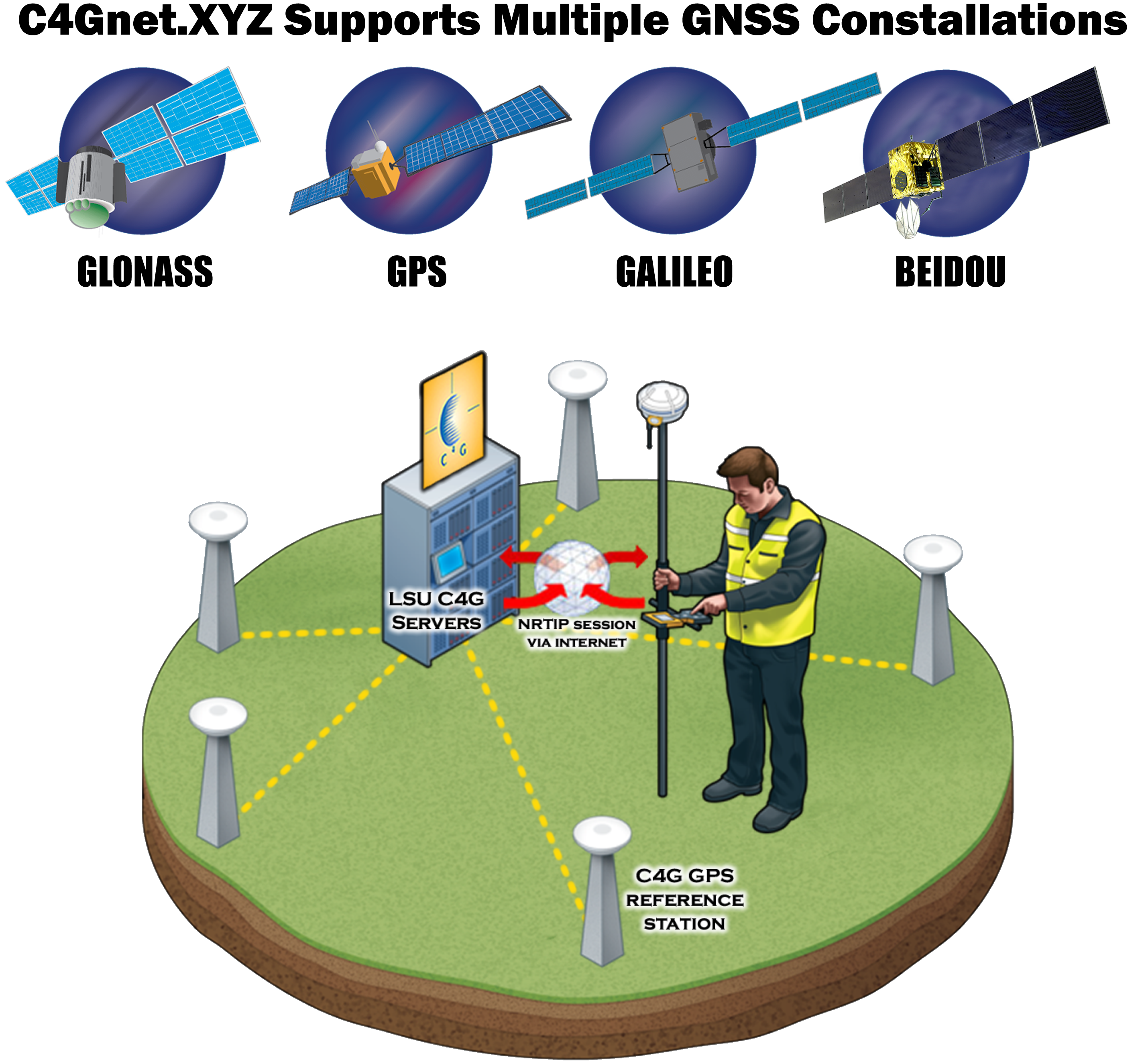
How Virtual Reference Station Networks Work
C4Gnet.XYZ VRS Now provides positioning professionals with instant access to Real-Time Kinematic (RTK) and Post-Processing (PP) corrections utilizing a network of permanent (fixed) reference stations. With no base station or setup required, it is cost-effective, efficient and simple to use GPS/GNSS positioning based on a set of reference stations. Simply Connect. Correct. Measure.
C4Gnet.XYZ Coverage
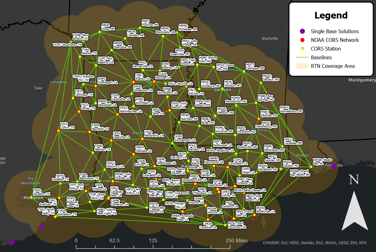
C4Gnet.XYZ Coverage in Louisiana Today
The C4Gnet.XYZ VRS network footprint spans across Louisiana, providing instant access to high accuracy positioning anywhere coverage is indicated on the adjacent map.
- Comprising of over 130 GNSS reference stations
- Extensive coverage area of over 60,000 square miles
- Providing continuous 24-hour data for increased field crew productivity
C4Gnet.XYZ is a Virtual Reference Station (VRS) network providing high accuracy GNSS correction signals to anyone needing precise advanced positioning in real-time with services optimized but not limited to Agriculture, Geospatial, Mapping, GIS, Construction and UAV markets.